Ben Macdui
<templatestyles src="Module:Hatnote/styles.css"></templatestyles>
| Ben Macdui | |
|---|---|
 |
|
| Highest point | |
| Elevation | Lua error in Module:Convert at line 1851: attempt to index local 'en_value' (a nil value). [1] |
| Prominence | Lua error in Module:Convert at line 1851: attempt to index local 'en_value' (a nil value). Ranked 9th in British Isles |
| Parent peak | Ben Nevis |
| Listing | Marilyn, Munro, Hardy, Council top (Aberdeenshire, Moray), County top (Aberdeenshire, Banffshire) |
| Naming | |
| Translation | Mountain of the son of Duff/MacDuff or Hill of the Black Pig (a reference to its shape) (Gaelic) |
| Pronunciation | Scottish Gaelic: [peɲ maʰkˈt̪ɯj] |
| Geography | |
| Location | Moray / Aberdeenshire, Scotland |
| Parent range | Cairngorms |
| OS grid | NN989989 |
| Topo map | OS Landranger 36, 43 |
Ben Macdui (Scottish Gaelic: Beinn Mac Duibh) is the second highest mountain in the United Kingdom after Ben Nevis, and the highest in the Cairngorms. After the defeat of Domnall mac Uilliam in 1187, Donnchad II, Earl of Fife, acquired Strathavon, territory stretching from Ballindalloch to Ben Macdui; because the mountain marked the western boundary of Donnchad's territory, historian and place-name scholar Professor G. W. S. Barrow suggested that the mountain took its name from Donnchad's family, the Mac Duibh.[2]
Ben Macdui lies on the southern edge of the Cairn Gorm plateau, on the boundary between Aberdeenshire and Moray.
Probably the easiest route of ascent is from the Coire Cas car park at the foot of Cairngorm Ski Centre by way of a path that leads up over slowly rising moorland. This route is about 7 km (4 mi) long; a somewhat longer route allows one to also climb Cairn Gorm. One possible alternative route follows the path coming up from Loch Etchachan. This loch may be reached from Loch Avon to the north or by coming up from Glen Derry to the South. Other routes include coming over Derry Cairngorm, or via the Lairig Ghru pass, which lies to the west of Ben Macdui.
Nearly all these routes are long days by Scottish standards. When coming from the south it is common to use a bicycle to cover the 4 km (2½ mi) separating the road end at Linn of Dee from Derry Lodge at the southern end of the massif.
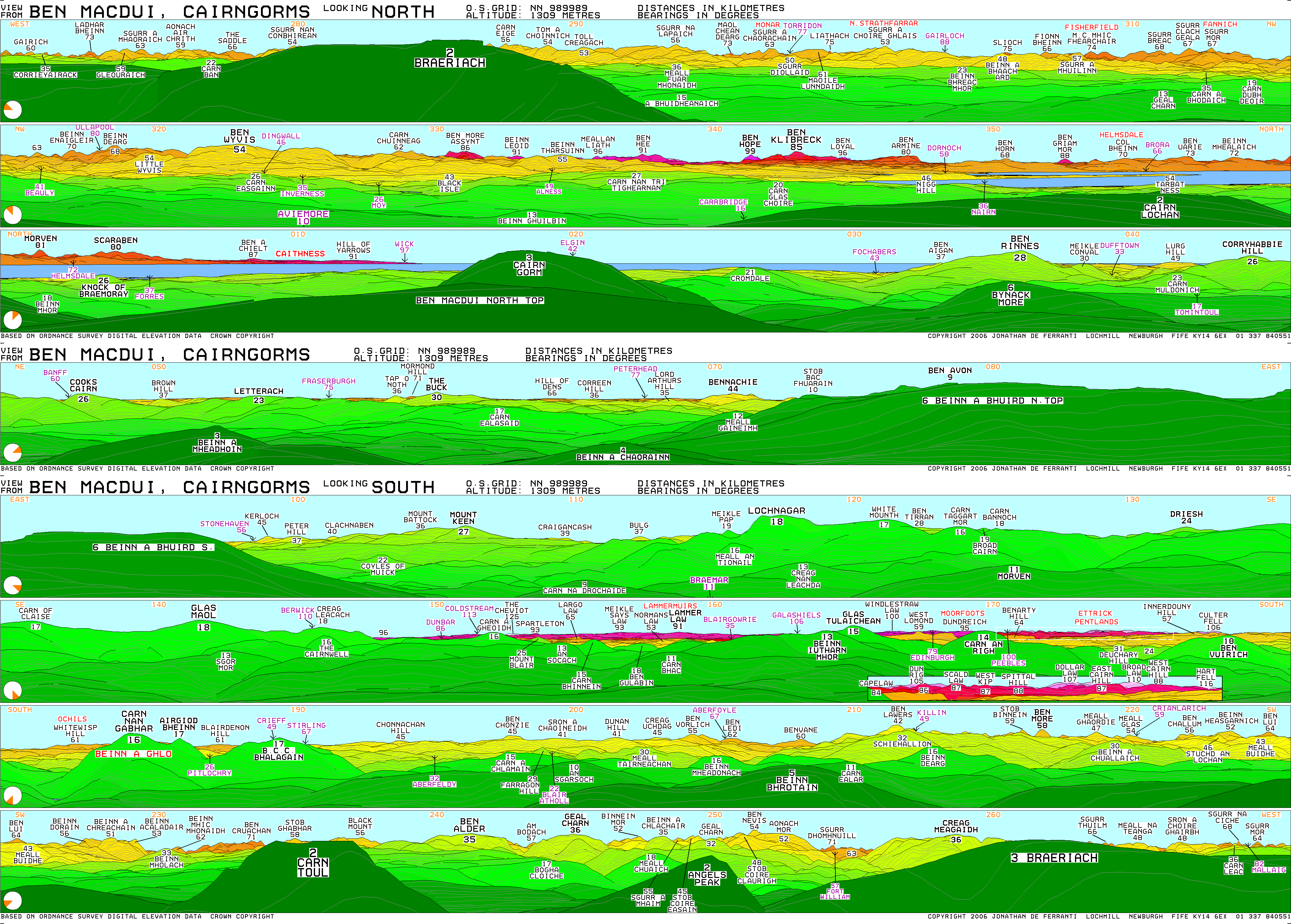
Before the production of accurate maps of Scotland in the nineteenth century it was not known for certain that Ben Nevis was the highest point in Britain, and it was often thought that Ben Macdui might be the higher. After Ben Nevis was confirmed as the higher some locals planned to build a cairn on the top of Ben Macdui to make its height greater than the Lochaber peak, but these plans did not come to fruition. The summit of the mountain has a direction indicator erected in 1925 by the Cairngorm Club of Aberdeen in memory of a past president, Mr. Alexander Copland. The indicator shows the direction of the most important hills that can be seen from the summit in clear weather.
It is claimed that Ben Macdui is the home of Am Fear Liath Mòr (the "big grey man of Ben Macdui"). Opinion is divided as to the substance behind this reported phenomenon, which it is claimed resembles either a Brocken spectre or a yeti.
Snow-patches have been known to persist at various locations on Ben Macdui, most notably Garbh Uisge Beag.
Contents
Gallery
-
Summit of Ben MacDui - geograph.org.uk - 50972.jpg
Summit of Ben Macdui
-
Ben Macdhui summit indicator.jpg
Summit indicator erected by the Cairngorm Club in 1925
-
Western side of Beinn Mheadhoin - geograph.org.uk - 202575.jpg
View from Beinn Mheadhoin
-
The Devil's Point , Munro No 130 - geograph.org.uk - 239563.jpg
View from The Devil's Point
Notes
<templatestyles src="Reflist/styles.css" />
Cite error: Invalid <references> tag; parameter "group" is allowed only.
<references />, or <references group="..." />References
- Lua error in package.lua at line 80: module 'strict' not found.
- Bennett, Donald, et al., The Munros, SMC Hillwalkers' Guide (Scottish Mountaineering Trust, 1985). ISBN 0-907521-13-4
- McNeish, Cameron, The Munros: Scotland's Highest Mountains, 2nd ed. (Lomond Books, 1998). ISBN 0-947782-50-8
| Wikimedia Commons has media related to Ben Macdui. |
External links
- ↑ Lua error in package.lua at line 80: module 'strict' not found.
- ↑ Barrow 1980, p. 86.
- Ben Macdui is at coordinates Lua error in package.lua at line 80: module 'strict' not found.
- Computer-generated virtual panorama from Ben Macdui
- Short documentary film about The Big Grey Man of Ben Macdui
 |
|
||
| Northern Highlands |
   |
|
|---|---|---|
| Western Highlands | ||
| Central and Eastern Highlands |
||
| Southern Highlands | ||
| Islands | ||
| Scottish Lowlands, England and Wales |
||
- Pages with broken file links
- Pages with reference errors
- Articles with OS grid coordinates
- Articles containing Scottish Gaelic-language text
- Commons category link is defined as the pagename
- Munros
- Marilyns of Scotland
- Hardys of Scotland
- Mountains and hills of Moray
- Mountains and hills of Aberdeenshire
- Places and place names on Mar Lodge Estate
- Reportedly haunted locations in Scotland
- Highest points of historic Scottish counties
- One-thousanders of the British Isles