Ramat Yishai
Ramat Yishai
|
||
|---|---|---|
| Hebrew transcription(s) | ||
| • ISO 259 | Ramat Yiššay | |
 |
||
|
||

Ramat Yishai
|
||
| Coordinates: Lua error in package.lua at line 80: module 'strict' not found. | ||
| District | Northern | |
| Founded | 1925 | |
| Government | ||
| • Type | Local council (from 1958) | |
| • Head of Municipality | Ofer Ben-Eliezer | |
| Area | ||
| • Total | 2,388 dunams (2.388 km2 or 590 acres) | |
| Population (2010) | ||
| • Total | 6,600 | |

Ramat Yishai (Hebrew: <templatestyles src="Script/styles_hebrew.css" />רָמַת יִשַּׁי, Jesse's Heights; Arabic: رمات يشاي) is a town in the North District of Israel, located on the side of the Haifa–Nazareth road about 4 kilometres (2.5 mi) eastern to Kiryat Tivon. It achieved local council status in 1958. According to the Israel Central Bureau of Statistics (CBS), it had a population of 6,600 in 2010, with a growth rate of 6.3%. The vast majority of the citizens of the village are Jewish.
Contents
History
Ottoman era
During the Ottoman era was here a Muslim village called Jeida.[1] The village appeared as Geida on the map which Pierre Jacotin compiled in 1799.[2]
In 1859, the village of Jeida was estimated to have 120 inhabitants, and the tillage was 20 feddans.[3] In 1875 Victor Guérin found rock-cut cisterns here.[4][5] In 1881, the Palestine Exploration Fund's Survey of Western Palestine (SWP) found that Jeida was much like Al-Harithiyah, but with houses of adobe. A spring existed 3/4 of a mile to the west.[3]
British Mandate era
In the 1922 census of Palestine conducted by the British Mandate authorities, Jaida had a total population of 327; 324 Muslims and 3 Christians;[6] of which two were Roman Catholics and one was Melchite.[7]
In 1925 a Zionist organisation purchased 15,000 dunams in Jaida from the heirs of the Twsiny family (partners of the Sursuk family of Beirut.) At the time, there were 110 families living there.[8]
At the time of the 1931 census, Jeida had 29 occupied houses and a population of 77 Jews, 2 Christians, and 33 Muslims; a total of 115.[9]
The land, on the western edge of the Jezreel Valley, which belonged to the village of Jida, was bought by a group of American Zionists in the early 20's. It was renamed Manor and then Yefe Nof, but was almost deserted after a few years. In 1925, the British philanthropist Yisrael Yehudah Adler saved it from bankruptcy and it was renamed in his honour shortly thereafter.[10] Among the establishers of the village were 50 families from Łódź and Białystok who built a textile factory in the village. Weaving and textile manufacturing were, therefore, the local trades.[citation needed]

One of the most known buildings in the village is called "the Khan", a 1909 building with surrounding walls. The logo of the village consists of this Ottoman-era building with a palm tree next to it. The town hall flies 2 logo-on-bedsheet flags with this emblem in dark blue on a light blue and a yellow field, respectively.[citation needed]
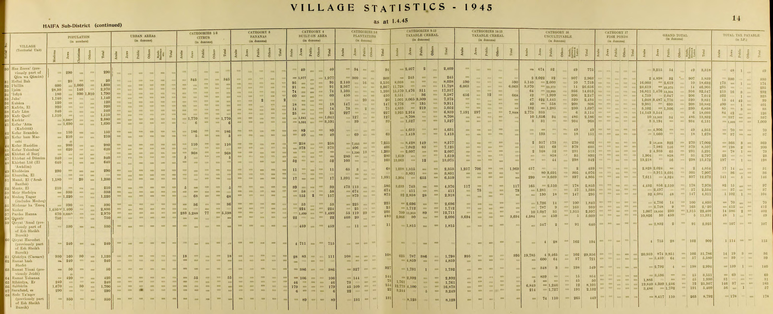
By 1945, Ramat Yishai had 50 residents, all Jewish. It was noted that it was previously called Jeida.[11][12]
The first residents were Yemenite Jews, later joined by immigrants from Romania.[13]
State of Israel
Since the 1990s, Ramat Yishai has undergone rapid development. In 2010, the population was estimated at close to 7,000 people, with 1,800 households at the high end of the socioeconomic scale.[14]
Notable residents
References
- ↑ from personal name. In Arabic it means "long-necked", according to Palmer, 1881, p. 109
- ↑ Karmon, 1960, p. 163
- ↑ 3.0 3.1 Conder and Kitchener, 1881, SWP I, p. 270
- ↑ Guérin, 1880, p. 392
- ↑ Conder and Kitchener, 1881, SWP I, p. 308
- ↑ Barron, 1923, Table XI, Sub-District of Haifa, p. 33
- ↑ Barron, 1923, Table XVI, p. 49
- ↑ List of villages sold by Sursocks and their partners to the Zionists since British occupation of Palestine, evidence to the Shaw Commission, 1930
- ↑ Mills, 1932, p. 92
- ↑ The Palgrave Dictionary of Anglo-Jewish History, edited by William D. Rubinstein
- ↑ Department of Statistics, 1945, p. 14
- ↑ Government of Palestine, Department of Statistics. Village Statistics, April, 1945. Quoted in Hadawi, 1970, p. 49
- ↑ Betting on the Trans-Israel Highway
- ↑ Betting on the Trans-Israel Highway
Bibliography
| Wikimedia Commons has media related to Ramat Yishay. |
- Lua error in package.lua at line 80: module 'strict' not found.
- Lua error in package.lua at line 80: module 'strict' not found.
- Lua error in package.lua at line 80: module 'strict' not found.
- Lua error in package.lua at line 80: module 'strict' not found.
- Lua error in package.lua at line 80: module 'strict' not found.
- Lua error in package.lua at line 80: module 'strict' not found.
- Lua error in package.lua at line 80: module 'strict' not found.
- Lua error in package.lua at line 80: module 'strict' not found.
External links
- Ramat Yishai Official website
- Ramat Yishai on Galil-Net
- Jida, from Dr. Moslih Kanaaneh
- Survey of Western Palestine, Map 5: IAA, Wikimedia commons
- Articles containing Hebrew-language text
- Articles containing Arabic-language text
- Articles with unsourced statements from November 2015
- Commons category link is locally defined
- Northern District (Israel)
- Local councils in Israel
- Populated places established in 1925
- Local councils in Northern District (Israel)